Every bike tour has some low points. Day 10 was one of ours.
Stepping out of our hotel in Muttenz, the day looked promising. It was still cloudy, but it didn’t look like it would rain, and if it did, it would probably be brief. We set off without even taking out our rain jackets.
Leaving Muttenz, the route started towards the centre of Basel by passing through some urban areas and a few school yards. Then it started to rain. Not hard, but enough to merit a rain jacket.
Lovely.
The temperature was good, so we didn’t worry to much about the dampness and pressed on as the route got closer and closer to Basel. The Rhine was nowhere in sight. We were well away from the river at this point.
Nearing the centre of Basel, the route left the bike trail and joined the city streets as we plunged into the heart of Basel. The rain let up, and we even got a bit of sunshine. Despite Basel being a fairly large city, the streets were relatively calm, and the riding generally quite enjoyable.
After several kilometres and one small navigational mishap, we found ourselves back alongside the Rhine and back in the shadow of the Basel Cathedral. This was good news, because we really wanted to climb the cathedral’s tower and get a better view of the surrounding area.
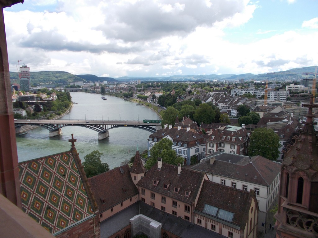
Enjoying the view, the day looked to be shaping up to be a good one. We were about to head out of the city and do some more riding in rural areas. I was exited about that. Better still, the sky seemed to be clearing.
Seemed to be…
Leaving the cathedral, the route continued parallel to the river towards the French border, passing briefly through another chaotic section of the city. Though busy, the experience of riding anywhere in Switzerland was never harrowing as the lanes are well marked and the vast majority of drivers are unbelievably accommodating.
Nearing the French border, it began to rain again, lightly at first. The border in sight, we pulled over to get our rain jackets on again and consult our guidebook about what direction the route would take in the coming kilometres.
Crossing into France, the signposting for the route began to rapidly deteriorate and the route suggested in the guidebook terminated at an industrial estate in a short distance. To add to the frustration, the rain worsened. Blah.
Wheeling around, we backtracked slightly to see if we had missed a turn, but found nothing. Confused, we opted instead to just ride generally in the direction of the river, hoping that we would be able to pick up the bike route again.
This approach to navigating turned out to be a good decision, and after riding past several industrial estates and a small urban area, we spotted a Rhine route marker and found ourselves back on a proper bike path. The rain stopped as well.
Continuing, the Rhine forked into a canal that runs alongside it for many kilometres. The route generally straight, we buckled down and brought the speed up a bit to make some time and hopefully avoid any further weather unpleasantness.
At Kembs, the canal forks again with the route staying on a smaller canal that heads north-west for a while before bending to the west.
After several kilometres on this smaller canal, we found ourselves standing at the Pont du Bouc war memorial and stopped to have some snacks.
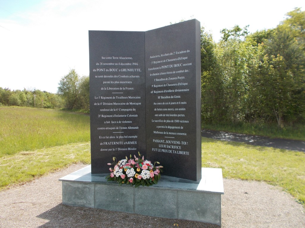
It was here that we made the worst navigational error of the entire tour. Getting back on our bikes, seeing no route signs indicating a turn, we continued on the bike path that paralleled the canal. Had we read our guide book more carefully we’d have recognized our mistake almost immediately, but this hadn’t happened, so instead we rode until we found ourselves in Riedisheim, a town that was clearly not mentioned in our book.
Having clearly erred, we consulted our guidebook and noted on a second reading that we were supposed to cross to the other side of the canal at Pont du Bouc before continuing. Frustrated, we turned around and headed back to Pont du Bouc. The mistake had cost us more than 15kms of extra riding.
Having returned to Pont du Bouc, with the weather still looking good, we crossed to the other side of the canal and turned immediately North into the thick of a huge forest.
From our guidebook we knew that the trail would continue for 25kms through the forest. Given that it was now early evening, we also knew that we would need to make up a lot of time to reach our destination at a reasonable hour. With the route flat and arrow straight, we muscled up and blasted through the distance in one continuous go, taking as aggressive a pace as we could maintain for the full distance.
The forest was beautiful, and the path completely quiet, so the experience of it all would have been quite relaxing under ordinary circumstances. The hustling negated any potential for relaxation though. Up ahead, we knew that we would have to ride several kilometres on a busy highway into Blodelsheim, and that doing so in poor lighting could potentially be hazardous.
After about 25 kms in the forest, we got to the highway and turned east to head into Blodelsheim. The traffic was moderate, but paired with the high speed of the cars and the slightly narrow shoulder, it wasn’t a road I would ever like to find myself on in the dark.
Coming into Blodelsheim, the route turned North again and the rain returned, this time in a big way. Having left the forest behind, we were now back in agricultural areas so we didn’t even have the benefit of nearby trees to shield us from some of the weather. It poured and we got drenched.
From Blodelsheim to our halt in Neuf-Brisach was another 20 kms of riding, mostly in heavy rain as we passed through several small towns. Given that we were back in the open country amidst farms, this section would have made for excellent riding, were it not for the cold, the rain, and the lingering frustration of our costly navigational mistake earlier that day.
With the sun having just gone down, we finally rolled into Neuf-Brisach and hunted for some overnight accommodation. Thoroughly knackered, we were pleased to find accommodation quickly, stashed the bikes, and settled down for a meal in the hotel’s restaurant.
It had been a very hard day. The distance was totally manageable, but the detour and the rain wore hard on our spirits.
I ordered steak, escargot and fries. It turned out to be a top 3 meal from the entire tour; proof that no matter what happens, there’s always a high point when touring on the Rhine.
Full of steak, I went to sleep wishing for better weather and better signposting the next day.
Day’s Stats
Distance ridden: 98.3 km
Max speed: 34.9 km/h
Average speed: 19.2 km/h
Seat time: 5:06
Total distance: 700 km
I am reminded of the many deeply awful days I have had touring. Wet and tired, grumpy, freezing and lost – it seems irretrievable and then – a hot shower, a meal (always ambrosial, be it fish and chips or porterhouse), a sunbeam before dusk – it doesn’t get any better. I can’t decide whether it’s merely that pleasure is the absence of pain or whether the bike gods first test and then reward.