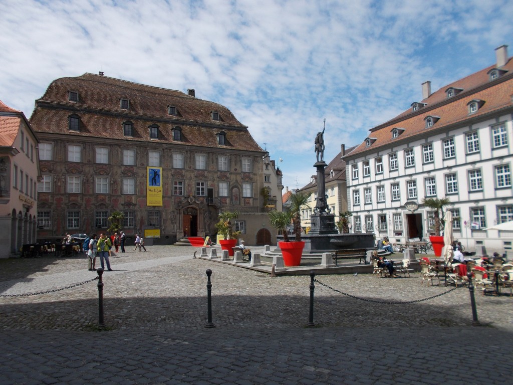
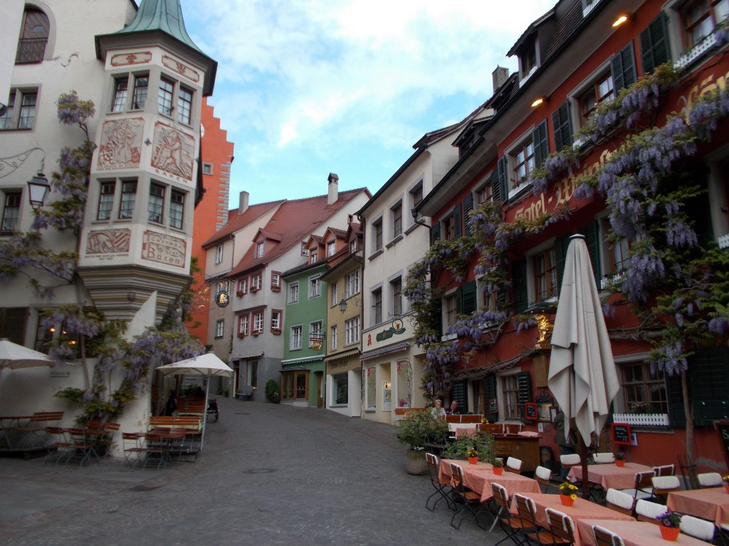
Strasbourg was every bit as pretty as its reputation suggested. It’s certainly a city that must be seen when in the area.
Navigating the streets, I noticed how much noisier and chaotic life seemed to be in the city compared to the bike seat where I had spent the past 11 days. Did I even need a rest day?
No matter. As far as places to walk around go, Strasbourg was about as good as it comes. Completely picturesque from nearly every angle, Strasbourg is surely a photographer’s dream. Full of activity and seemingly unlimited shopping options, it also struck me as a place one could spend days poking through shops on the many streets that cross this way and that in its interior.
Lacking good photography equipment and possessing limited cargo room for any purchased goods, we instead spent our time admiring the architecture and finding as many edible treats as we could. Strasbourg delivered, and we had a great time.
As a side note, I will add that for ordinary tourist purposes, one day is far too short a stay to fully enjoy Strasbourg. It’s a large city, and a scenic one at that, so a proper exploration of all that it has to offer would take far more time than we allotted.
Was it a good spot for a rest day? Maybe. It’s a great city to walk around in, but don’t expect that you’ll be able to take in all that it offers on just one day out of the bike saddle.
A few pictures from Strasbourg:
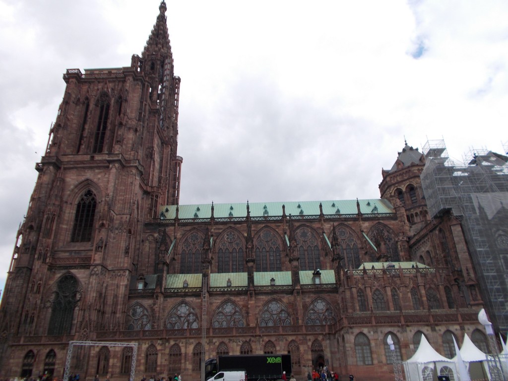
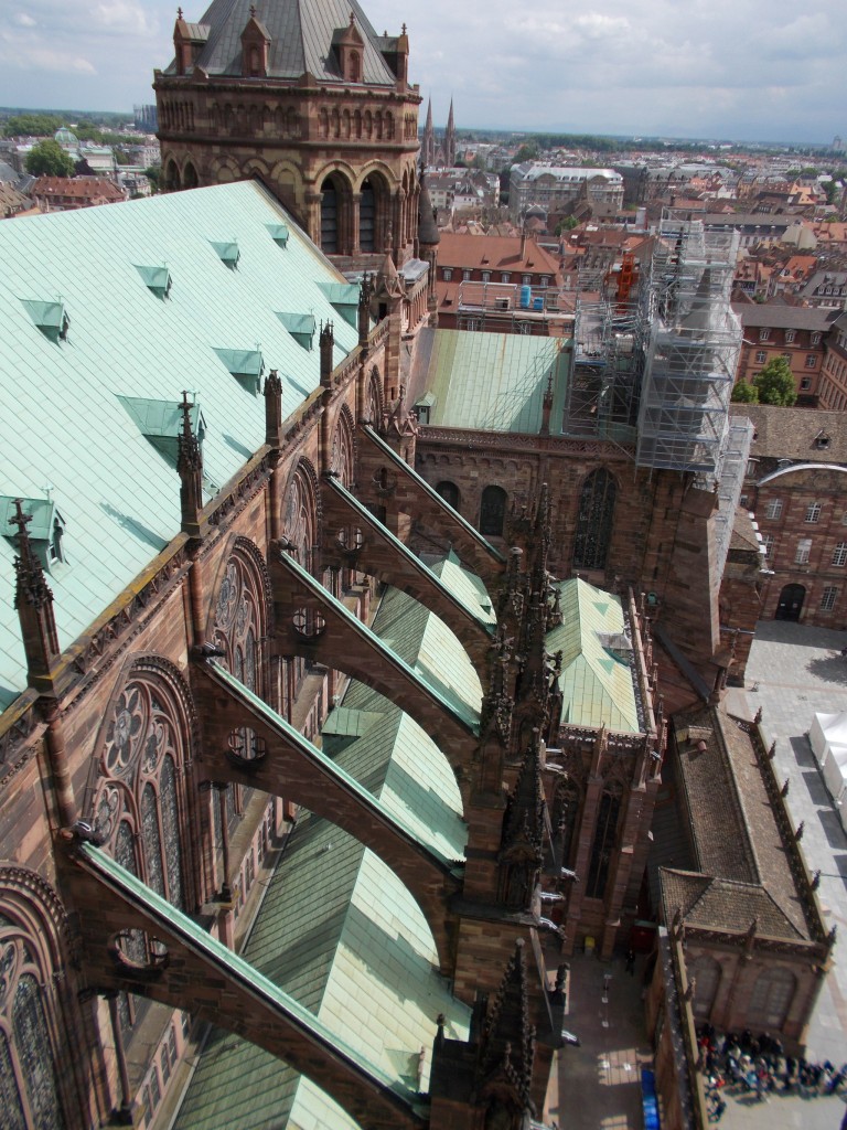
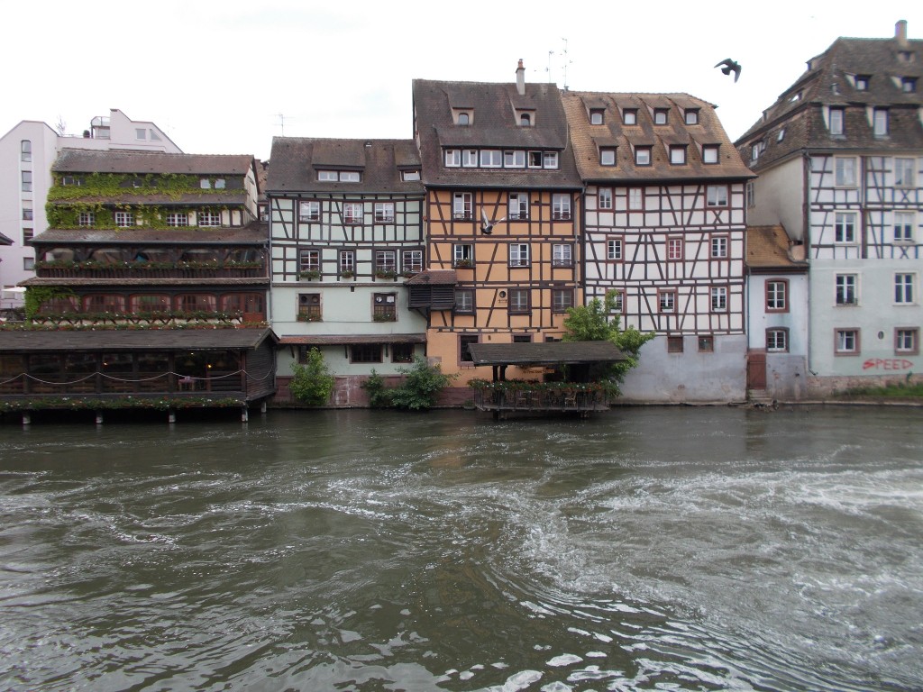
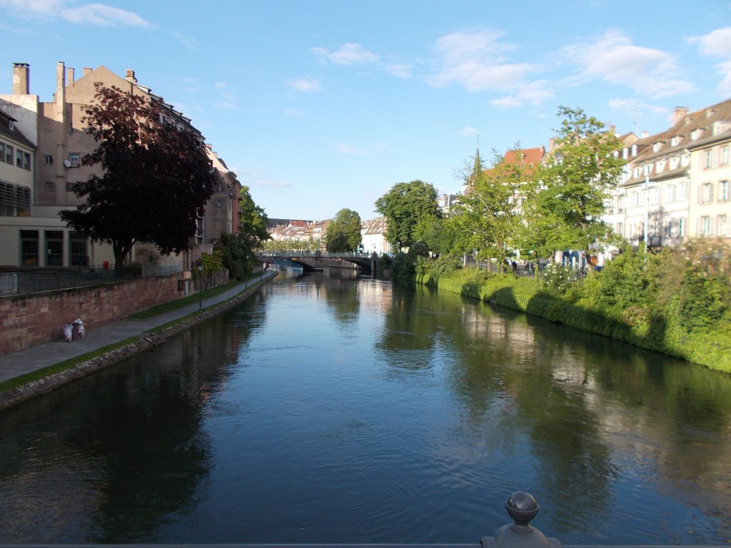
The stunningly beautiful Notre Dame Cathedral. This massive cathedral is a must see sight in the centre of Strasbourg. Towing high above the surrounding buildings, its towers can be climbed for a great view of the region at a very minimal cost. Though the stairways are steep and narrow, the view from the top is worth every step. May 15, 2014 – Strasbourg, France.The flying buttresses on Notre Dame Cathedral as photographed from the stairwell of one of the towers. May 15, 2014 – Strasbourg, France.Beautiful buildings lining the waterway in the Petite France district of Strasbourg, France. May 15, 2014 – Strasbourg, France.The L’Ill waterway as it passes through the Petite France district of Strasbourg, France. May 15, 2014 – Strasbourg, France.
Having awoken in Neuf-Brisach, we glanced outside to see that the weather had mostly cleared and that is was shaping up to be a much nicer day than the last. That was very welcome news.
After a fantastic breakfast at the hotel, we gathered up our gear and were about to set out when #1 noticed that several of his spokes were loose. Though mechanical problems are never welcome on a bike, we were at least glad that we could make a quick repair under sunny skies rather than torrential rain.
#1 re-tightened and trued his wheel in short order, and we were on our way, stopping briefly at a local supermarket to pick up a bit of chocolate, sausages, cheese, bread, and some carrots to have for lunch.
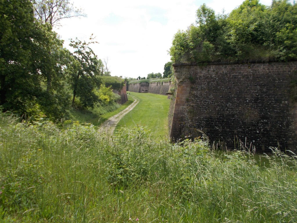
Leaving Neuf-Brisach, we passed through the town’s wall and finally got a proper view of the epic fortifications that make Neuf-Brisach unique. Huge walls surround the entire town and serve as a permanent reminder that Neuf-Brisach was actually built as a border guard town in the early 1700s. The fortifications are well worth a visit.
The fortified walls of the French town of Neuf-Brisach. Built in the early 1700s, Neuf-Brisach was designed to guard the French border in the region. Though damaged in World War II, the walls still surround the entire town and are worth a stop to check out. May 14, 2014 – Neuf-Brisach, France.
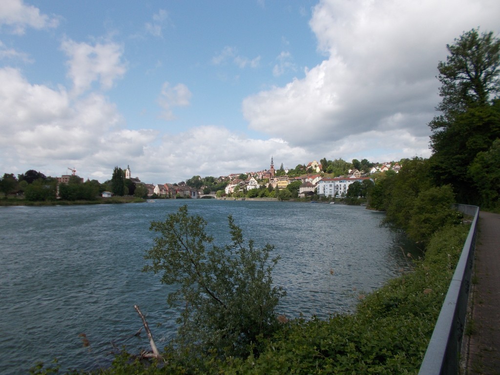
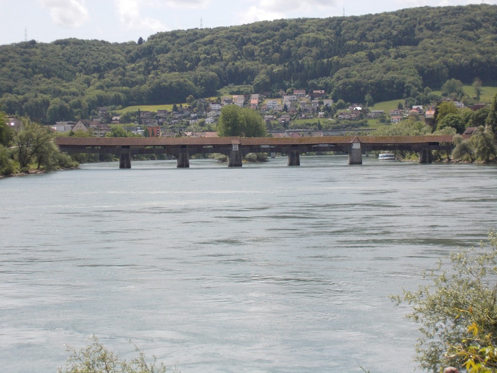
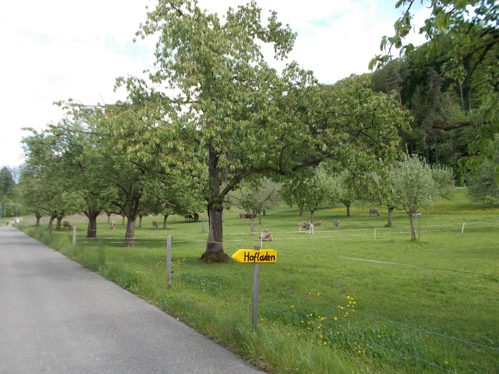
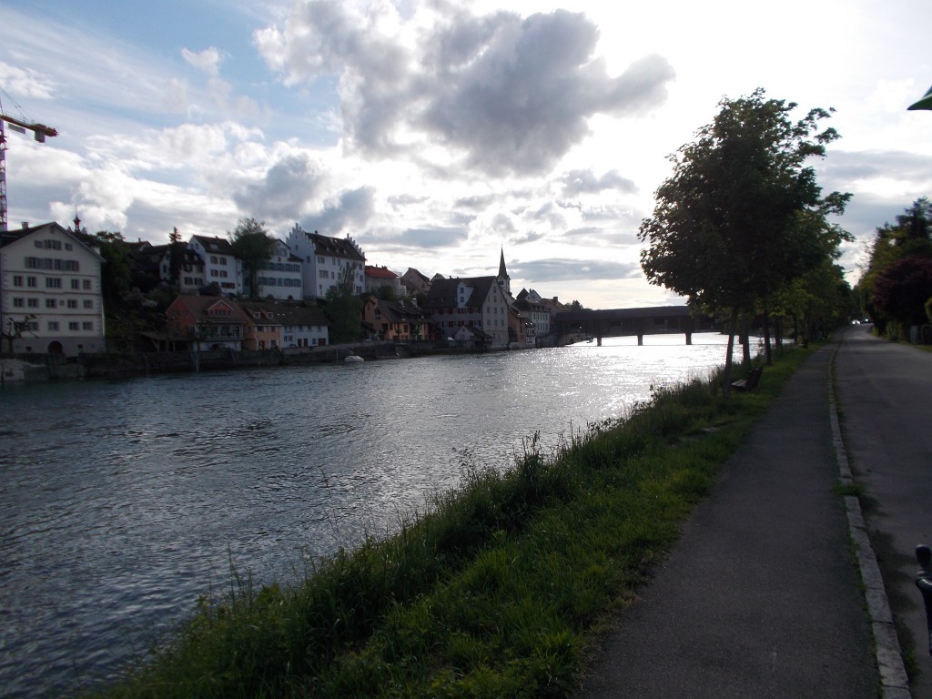
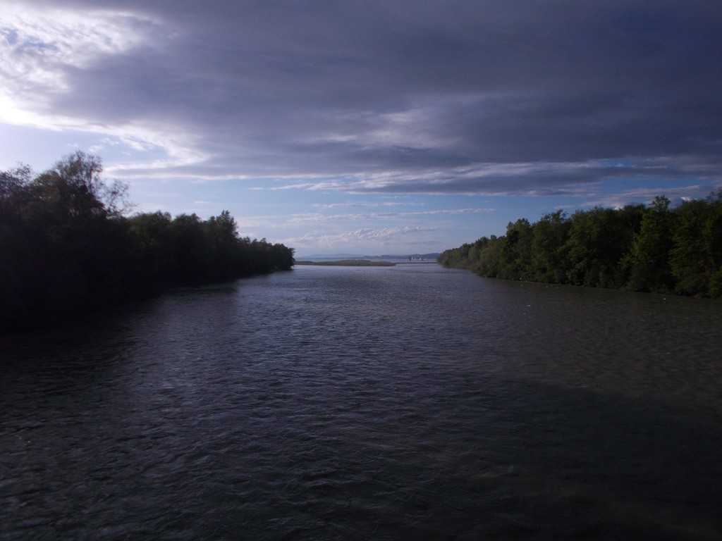
Exiting Neuf-Brisach, the route took us first through some fields and the town of Biesheim before guiding us onto a tow-path alongside a canal. Turning North, the canal took us quickly to the town of Kunheim where it joined the larger Canal du Rhône au Rhin (Rhone-Rhine Canal).
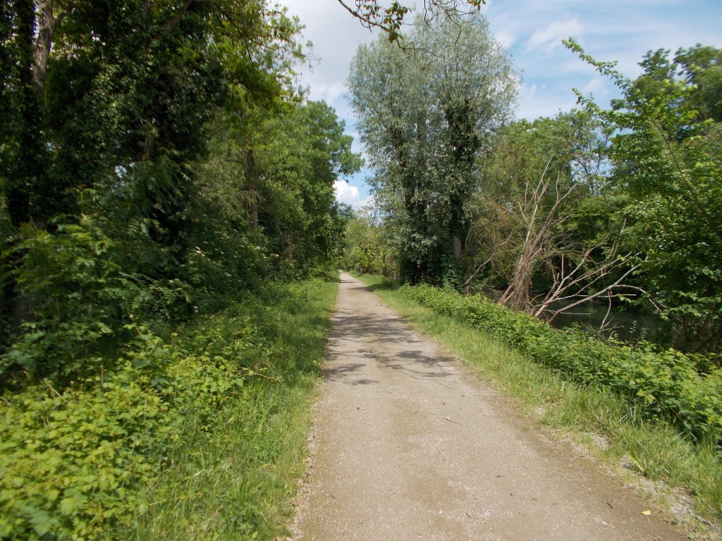
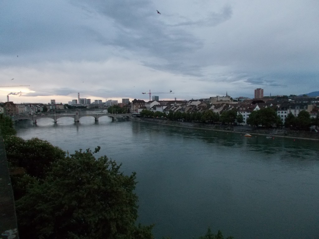
From there, the route would follow the canal for 60 kilometres into Strasbourg, offering just a few sights to see along the way. The tow-path that parallels the canal is in great shape and perfect for riding on, so we covered distance very quickly. This was good news, because as the canal is arrow-straight and lined with trees, the scenery got quite boring long before we had completed the full distance.
A snapshot of the path that follows the Canal du Rhône au Rhin as it makes nearly a perfectly straight shot into Strasbourg, France. Completely flat, the route follows this path for many kilometres and is a great place to make up time. May 14, 2014 – France.
Passing Artzenheim, we decided to dip into the town for a few minutes and see if there was much to see. Though it was just past 1:00pm, we found little going on and decided to press on after just several minutes in town. The relative quietness of the French towns was something we found to be quite common during our time in France. During the day, many of the towns we visited seemed to be nearly deserted. I expect this must be because the locals were either working in the surrounding agricultural areas or in the larger cities.
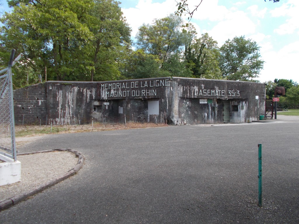
Rejoining the canal path, we rode for several more kilometres before making a suggested stop at the Maginot Line Memorial just outside of Marckolsheim, France. Built in the lead up to World War II, the Maginot Line fortified the French border for hundreds of kilometres, particularly the French-German border. Generally intact, components of the Maginot Line ranging from full casemates to small blockhouses are visible in many places along the Rhine route.
The exterior of the Maginot Line Memorial Museum just outside of Marckolsheim, France. Just a few minutes ride off the Rhine cycle route, this memorial and its small museum are an absolute must see. The grounds contain many reminders of the World War II battles that were fought here, and within the museum there is an impressive array of artefacts that are worth seeing. May 14, 2014 – Marckolsheim, France.
The memorial itself is worth a stop because the casemate can be entered to view the interior which houses a small museum. Located just a few minutes riding off the main route, it’s a must stop. We took many pictures and spent far longer than we planned enjoying the sights.
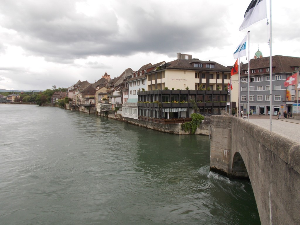
Leaving the memorial, we again rejoined the canal and quickly realized we were in danger of being very late to meet the proprietor of our overnight accommodation if we didn’t put the hammer down and ride as quickly as possible into the southern end of Strasbourg.
No matter, the tow-path continued to be completely straight, flat, and offered little to catch the eye. Thank goodness it was such a nice day. We made great time, found our way to our overnight halt, stashed the bikes, and went into Strasbourg to have some dinner.
Legs no longer getting sore after a day of riding, I hoped that Strasbourg would be well worth a stop. We had planned Strasbourg as our only rest day on the tour. No riding was planned for the following day; it was time to practice some walking.
Day’s Stats
Distance ridden: 80.21 km
Max speed: 31.6 km/h
Average speed: 19.7 km/h
Seat time: 4:03
Total distance: 780 km
Every bike tour has some low points. Day 10 was one of ours.
Stepping out of our hotel in Muttenz, the day looked promising. It was still cloudy, but it didn’t look like it would rain, and if it did, it would probably be brief. We set off without even taking out our rain jackets.
Leaving Muttenz, the route started towards the centre of Basel by passing through some urban areas and a few school yards. Then it started to rain. Not hard, but enough to merit a rain jacket.
Lovely.
The temperature was good, so we didn’t worry to much about the dampness and pressed on as the route got closer and closer to Basel. The Rhine was nowhere in sight. We were well away from the river at this point.
Nearing the centre of Basel, the route left the bike trail and joined the city streets as we plunged into the heart of Basel. The rain let up, and we even got a bit of sunshine. Despite Basel being a fairly large city, the streets were relatively calm, and the riding generally quite enjoyable.
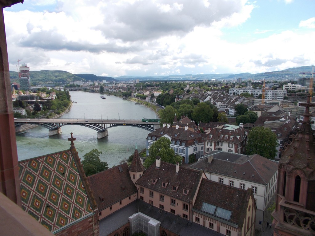
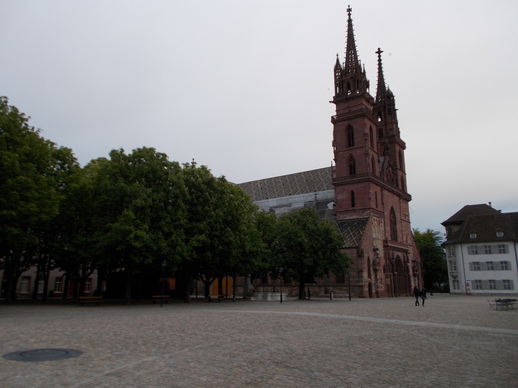
After several kilometres and one small navigational mishap, we found ourselves back alongside the Rhine and back in the shadow of the Basel Cathedral. This was good news, because we really wanted to climb the cathedral’s tower and get a better view of the surrounding area.
A view of the Rhine as seen from the top of the Basel Cathedral. Climbing the cathedral steps is well worth the effort to catch a glimpse of the surrounding area. Basel, Switzerland – May 13, 2014.
Enjoying the view, the day looked to be shaping up to be a good one. We were about to head out of the city and do some more riding in rural areas. I was exited about that. Better still, the sky seemed to be clearing.
Seemed to be…
Leaving the cathedral, the route continued parallel to the river towards the French border, passing briefly through another chaotic section of the city. Though busy, the experience of riding anywhere in Switzerland was never harrowing as the lanes are well marked and the vast majority of drivers are unbelievably accommodating.
Nearing the French border, it began to rain again, lightly at first. The border in sight, we pulled over to get our rain jackets on again and consult our guidebook about what direction the route would take in the coming kilometres.
Crossing into France, the signposting for the route began to rapidly deteriorate and the route suggested in the guidebook terminated at an industrial estate in a short distance. To add to the frustration, the rain worsened. Blah.
Wheeling around, we backtracked slightly to see if we had missed a turn, but found nothing. Confused, we opted instead to just ride generally in the direction of the river, hoping that we would be able to pick up the bike route again.
This approach to navigating turned out to be a good decision, and after riding past several industrial estates and a small urban area, we spotted a Rhine route marker and found ourselves back on a proper bike path. The rain stopped as well.
Continuing, the Rhine forked into a canal that runs alongside it for many kilometres. The route generally straight, we buckled down and brought the speed up a bit to make some time and hopefully avoid any further weather unpleasantness.
At Kembs, the canal forks again with the route staying on a smaller canal that heads north-west for a while before bending to the west.
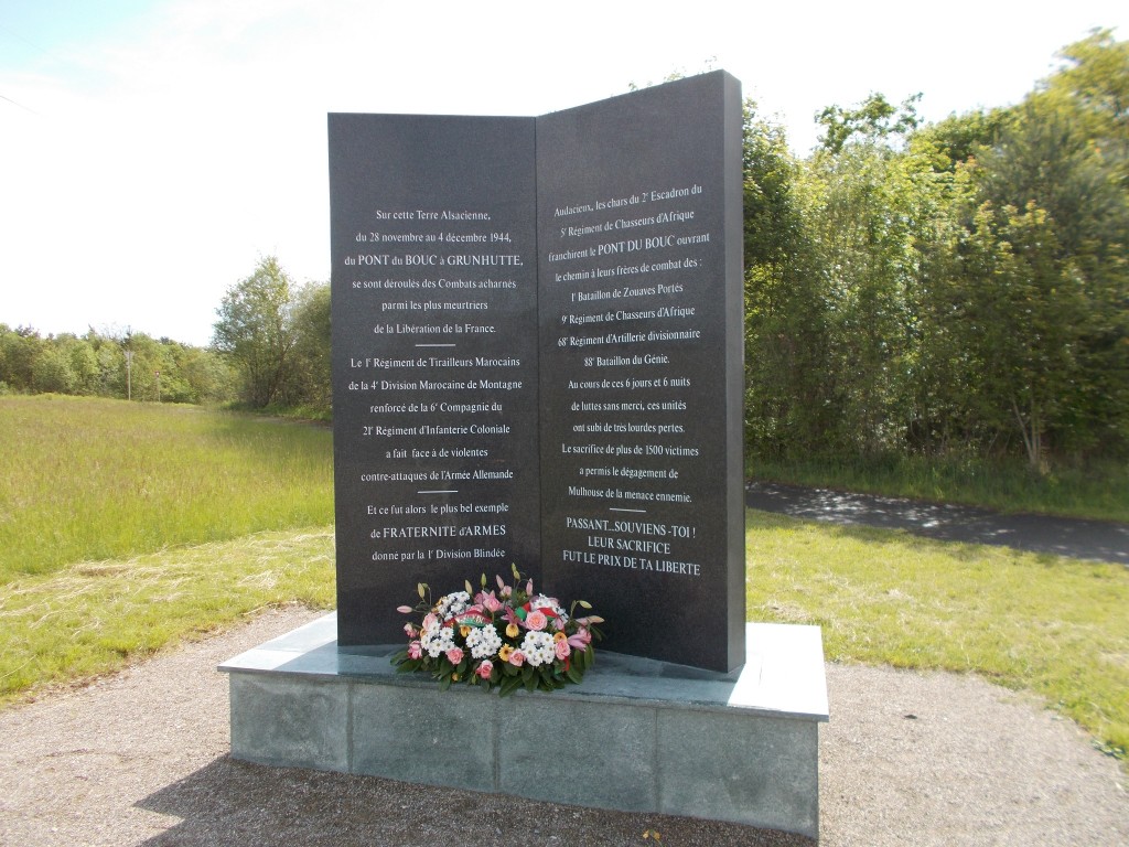
After several kilometres on this smaller canal, we found ourselves standing at the Pont du Bouc war memorial and stopped to have some snacks.
The memorial that stands at Pont du Bouc to honour more than 1500 French troops that lost their lives in a battle with the retreating German army in 1944. Pont du Bouc, France – May 13, 2014.
It was here that we made the worst navigational error of the entire tour. Getting back on our bikes, seeing no route signs indicating a turn, we continued on the bike path that paralleled the canal. Had we read our guide book more carefully we’d have recognized our mistake almost immediately, but this hadn’t happened, so instead we rode until we found ourselves in Riedisheim, a town that was clearly not mentioned in our book.
Having clearly erred, we consulted our guidebook and noted on a second reading that we were supposed to cross to the other side of the canal at Pont du Bouc before continuing. Frustrated, we turned around and headed back to Pont du Bouc. The mistake had cost us more than 15kms of extra riding.
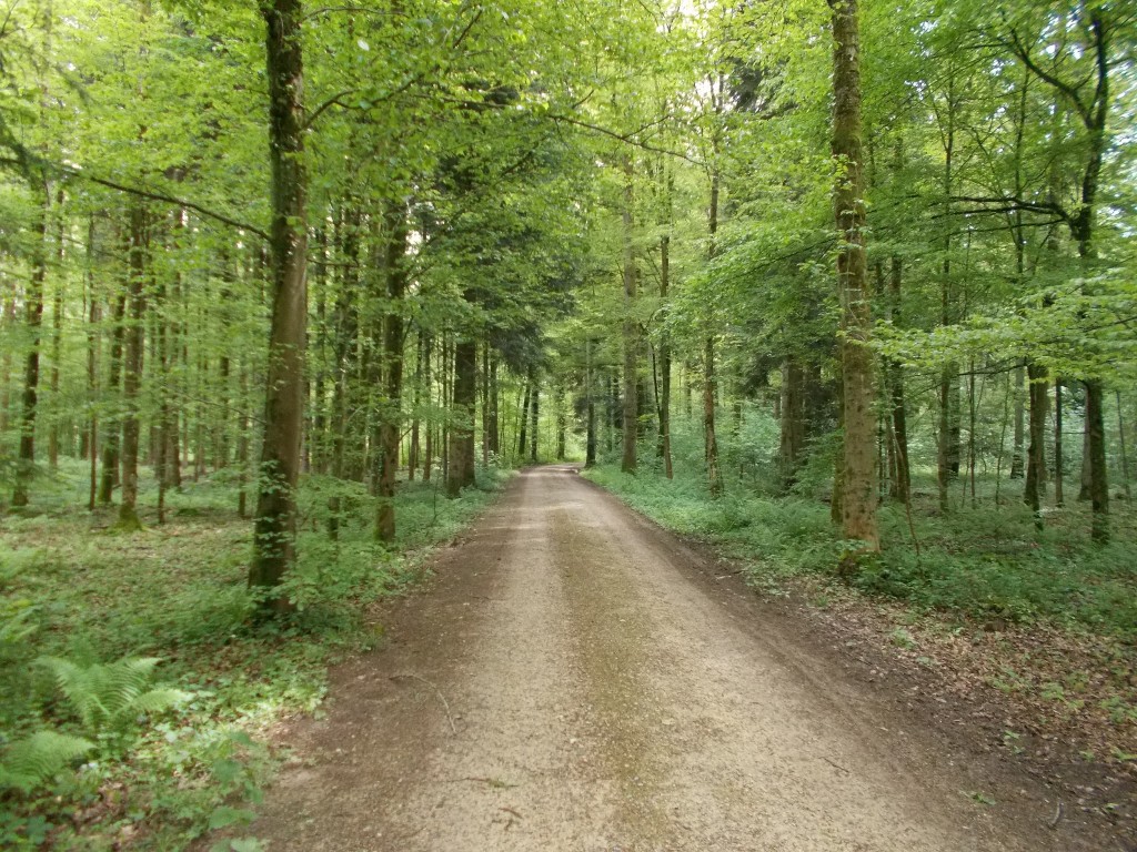
Having returned to Pont du Bouc, with the weather still looking good, we crossed to the other side of the canal and turned immediately North into the thick of a huge forest.
From our guidebook we knew that the trail would continue for 25kms through the forest. Given that it was now early evening, we also knew that we would need to make up a lot of time to reach our destination at a reasonable hour. With the route flat and arrow straight, we muscled up and blasted through the distance in one continuous go, taking as aggressive a pace as we could maintain for the full distance.
The forest was beautiful, and the path completely quiet, so the experience of it all would have been quite relaxing under ordinary circumstances. The hustling negated any potential for relaxation though. Up ahead, we knew that we would have to ride several kilometres on a busy highway into Blodelsheim, and that doing so in poor lighting could potentially be hazardous.
After about 25 kms in the forest, we got to the highway and turned east to head into Blodelsheim. The traffic was moderate, but paired with the high speed of the cars and the slightly narrow shoulder, it wasn’t a road I would ever like to find myself on in the dark.
Coming into Blodelsheim, the route turned North again and the rain returned, this time in a big way. Having left the forest behind, we were now back in agricultural areas so we didn’t even have the benefit of nearby trees to shield us from some of the weather. It poured and we got drenched.
From Blodelsheim to our halt in Neuf-Brisach was another 20 kms of riding, mostly in heavy rain as we passed through several small towns. Given that we were back in the open country amidst farms, this section would have made for excellent riding, were it not for the cold, the rain, and the lingering frustration of our costly navigational mistake earlier that day.
With the sun having just gone down, we finally rolled into Neuf-Brisach and hunted for some overnight accommodation. Thoroughly knackered, we were pleased to find accommodation quickly, stashed the bikes, and settled down for a meal in the hotel’s restaurant.
It had been a very hard day. The distance was totally manageable, but the detour and the rain wore hard on our spirits.
I ordered steak, escargot and fries. It turned out to be a top 3 meal from the entire tour; proof that no matter what happens, there’s always a high point when touring on the Rhine.
Full of steak, I went to sleep wishing for better weather and better signposting the next day.
Day’s Stats
Distance ridden: 98.3 km
Max speed: 34.9 km/h
Average speed: 19.2 km/h
Seat time: 5:06
Total distance: 700 km
Having taken a train out of Bad Säckingen the previous day to meet some friends, we actually began day 9 far away from the Rhine in the town of Niedergösgen. Though we had originally planned to take the train back to Bad Säckingen to resume the route, our host (who was an avid cyclist himself) suggest instead that we skip the train and cycle back instead.
Cycle instead of take a train? Yes please.
With the sky closing in, we loaded up and began a lengthy climb out of Niedergösgen and high into the hills. As we climbed, memories of our first day climbing out of Andermatt immediately came to mind. I was already missing the earlier stages of the route when climbing was a regular feature of the day.
After climbing for roughly an hour, we reached the summit and began an epic downhill that seemed to last forever. Because Niedergösgen is above the Rhine itself, and we had climbed further still, we had the rare privilege of descending much further than we had climbed.
Cheating? A bit. Totally worth it though.
As we descended through great farmland and lovely country towns, I decided that I would unquestionably need to return to Switzerland and just ride the hills outside of the cities. Though the Rhine route had been unbelievably good thus far, my favourite parts had exclusively taken place in rural areas. I knew that later that day we would be rolling into Basel and that I would miss the clattering bells of Swiss cows once more. As the kilometres rolled past I took every moment in; a last hurrah as our time in Switzerland thinned.
Emerging from the descent, per our host’s superb directions, we found ourselves exactly where we had boarded the train the day before. To fully reset the moment, we backtracked into Bad Säckingen, leaned our bikes against the cathedral and had a spot of lunch before pressing on.
Leaving Bad Säckingen, we again crossed the long wooden bridge into Stein and followed the route as it trailed next to a highway. It was at that point that the cloudy skies began to open up their taps and lay a drenching on us. It even hailed a bit. Lovely.
Fortunately it was not particularly cold, so spirits remained high, and were heightened further still as the route ceased to follow the highway and plunged into the Unterforst.
Much of the route leading into the city of Basel takes place on forest trails as pictured. As a final chance to enjoy some of Switzerland’s epic natural beauty, these forested segments are a real treat. Officially called the Unterforst, this natural preservation area spans many kilometres and is abundant in natural beauty. Unterforst, Switzerland – May 12, 2014.
Full of huge trees and richly vegetated, the Unterforst hosts the route for many kilometres and makes for a highly enjoyable segment of riding. Well signposted and with a trail that is generally in superb shape, I found this segment of the day to be profoundly relaxing. I selected a good gear, had a gulp of water, and settled in for several great kilometres while the rain soldiered on.
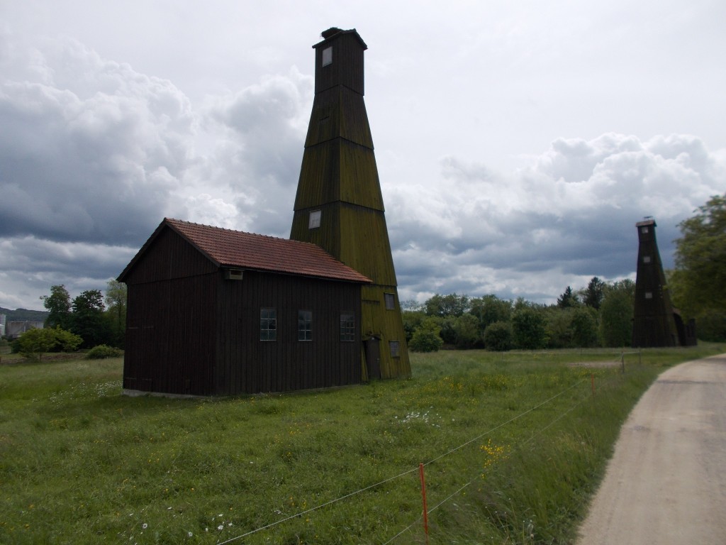
Nearing the edge of the forest, the rain let up, and we emerged into a more agricultural area fringed with some housing and industrial estates. It was here that we passed one of the many iconic sights along the Rhine route; the salt mine towers outside of Riburg. Due to their distinctive design and colour, the towers are impossible to miss and make for a great place to stop and take a memorable picture.
Unique to this segment of the Rhine cycle route, these salt mine towers make great landmarks. By passing these, any Rhine cyclist can confidently say that they are beyond one third done the entire route. Though inaccessible, it is possible to peer through the windows and catch a glimpse of what’s inside. Riburg, Switzerland – May 12, 2014.Grain fields near the Swiss town of Riburg. Having left the forest for a short while, the route traverses several agricultural areas before re-entering a forest leading into Rheinfelden. Riburg, Switzerland – May 12, 2014.
Beyond the salt mines, the route re-entered the forest for a short while before entering the town of Rheinfelden. Home to a great market street, it was also the last place in Switzerland that we stumbled on a public fountain with fantastic water. Water bottles refilled, and with a new threat of rain looming, we didn’t linger long pausing just to snap a few photos of the town and the Rhine from the bridge.
The Rhine as seen from the bridge between the Swiss and German sides of Rheinfelden. Rheinfelden, Switzerland – May 12, 2014.
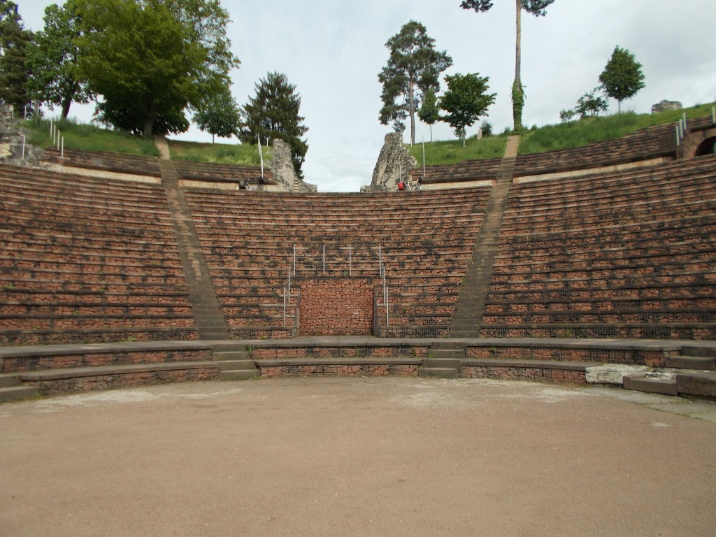
Beyond Rheinfelden the route passed mainly through urban areas and industrial estates with the Rhine itself generally in view. Approaching Augst, we made a lengthy stop to visit the Roman ruins of Augusta Raurica. This ancient amphitheatre is in remarkable shape (thanks in part to some restorative maintenance) despite having been founded in 44BC. In need of a rest, we spent nearly an hour in the area snacking and enjoying the view. Across the street from the amphitheatre we found additional Roman ruins, some with informative placards.
Founded in 44BC, Augusta Raurica is a notable Roman ruin that is available to visit on the Rhine route. A great place to take photographs, it is also features several informative placards to educate and inform. Further Roman architectural ruins are available across the street and are freely accessible. Augst, Switzerland – May 12, 2014.
Leaving Augst, the route continued to pass through urban and industrial areas. The countryside of Switzerland was now permanently behind us, and I had a mental funeral for the excellent times we had there. From there onward, our view of Switzerland would be exclusively the city of Basel and its connected cities.
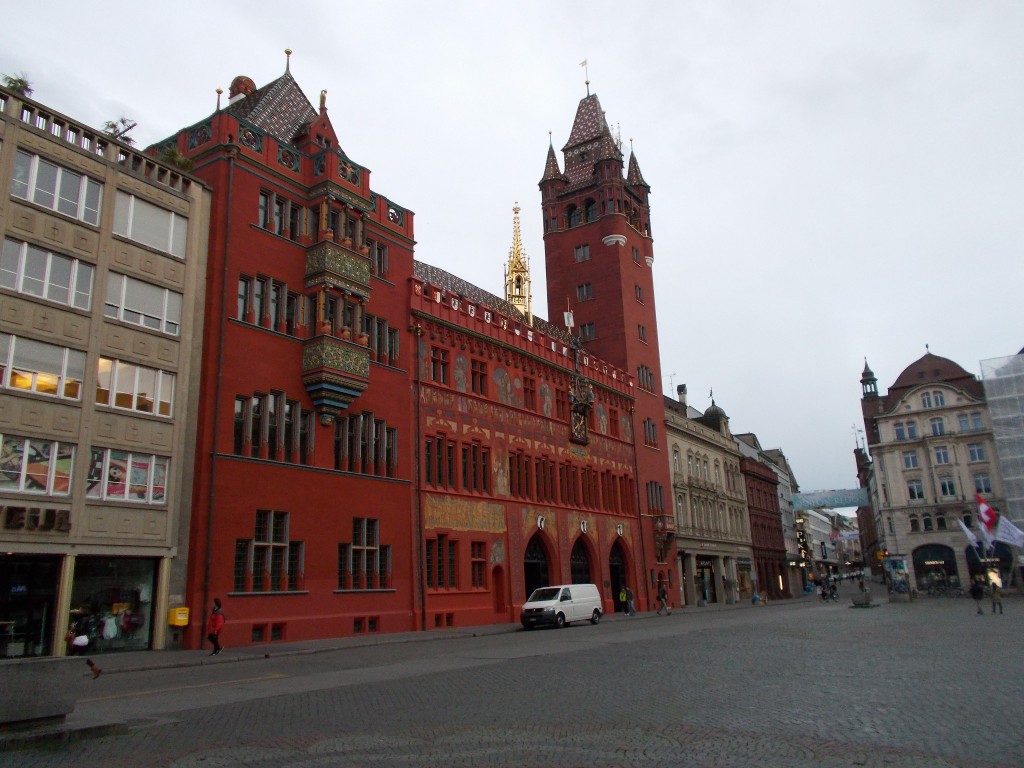
As it was getting late in the day and not wanting to combat the full chaos of a big city like Basel, we stopped just short of Basel proper and pulled up for the day in the city of Muttenz. Close enough to Basel that it includes Basel’s local tram service, Muttenz turned out to be a great place to make an overnight halt. Having quickly found a hotel, we freshened up and continued into the centre of Basel by tram and on foot to take in what we could as the daylight dwindled.
Among the most uniquely coloured buildings available for visit on the Rhine route, the Basel town hall is certainly worth a stop. Sitting on one side of Basel’s Marktplatz it makes a great starting point for further exploration of the city, particularly if you arrive via the Basel tram. Basel, Switzerland – May 12, 2014.An attraction of Basel that simply can’t be missed, the Basel Cathedral (or more correctly, Basler Münster) is among the largest and most beautiful that can be visited on the Rhine. Sitting atop a cliff overlooking the Rhine (now a huge river) it is also makes for an excellent place to take some pictures. Basel, Switzerland – May 12, 2014.The Rhine as seen from the lookout behind the Basel cathedral. At this point the Rhine is navigable by ships and barges and has completely matured beyond the small river it was in the early stages of our ride. Looking at this scene, I pondered the many things we had seen as the Rhine grew and grew. Once a water source for small country towns, it was now the major waterway for a huge city, beautiful still, but in an entirely new way. Basel, Switzerland – May 12, 2014.
Looking over the Rhine that night from the lookout behind Basel’s cathedral, I pondered the thousands of great moments Switzerland had given us. Though I didn’t know it yet, Switzerland had offered up what would become the vast majority of my all time favourite days of the entire tour. Looking out over the Rhine, now a massive river fully navigable by large barges, I missed places like Disentis and Altstätten. I’ll go back and see them again.
Day’s Stats
Distance ridden: 73.64 km
Max speed: 50.3 km/h
Average speed: 15.8 km/h
Seat time: 4:38
Total distance: 601 km
With day dawning, we loaded our bikes and got off to an earlier start than usual. The early departure wasn’t because we were feeling any more sprightly than other days; it was because this hotel was the first we’d ended up in that didn’t serve breakfast. No matter. We found a convenience store in minutes and fueled ourselves.
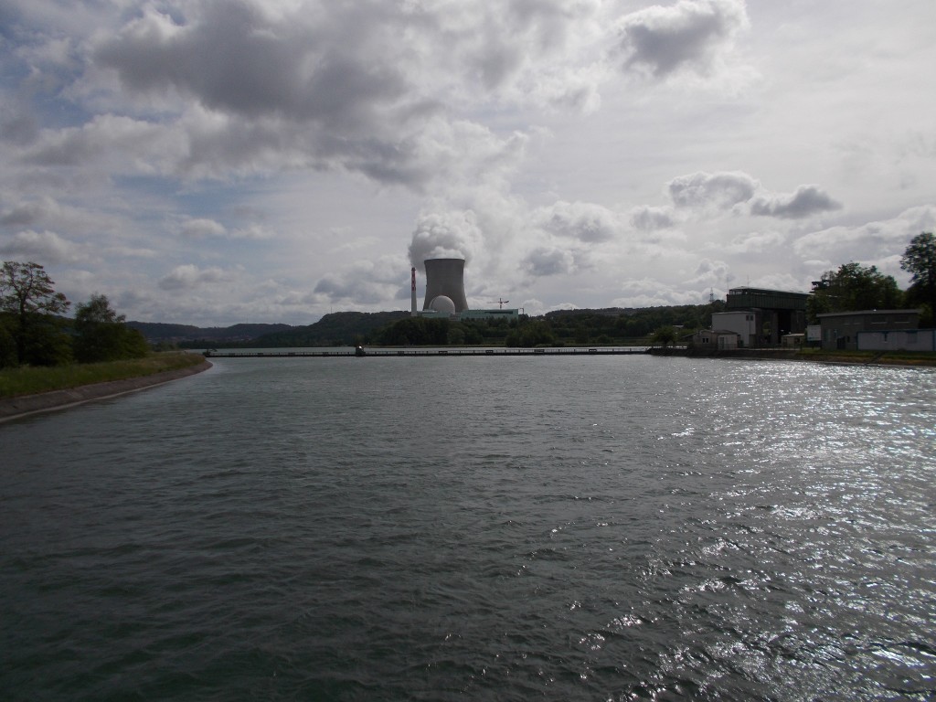
Leaving Waldshut, the route followed the bank of the river for a short distance before crossing half of the Rhine onto a reservoir built on an island in the center of the Rhine’s flow. With a nuclear power plant visible on the Swiss side of the Rhine, I wondered if the reservoir was actually for the power plant’s boilers and not for the locals to drink.
A nuclear power plant outside the town of Leibstadt, Switzerland as photographed from just outside Dogern, Germany. This was the first of several that we would see on our journey.
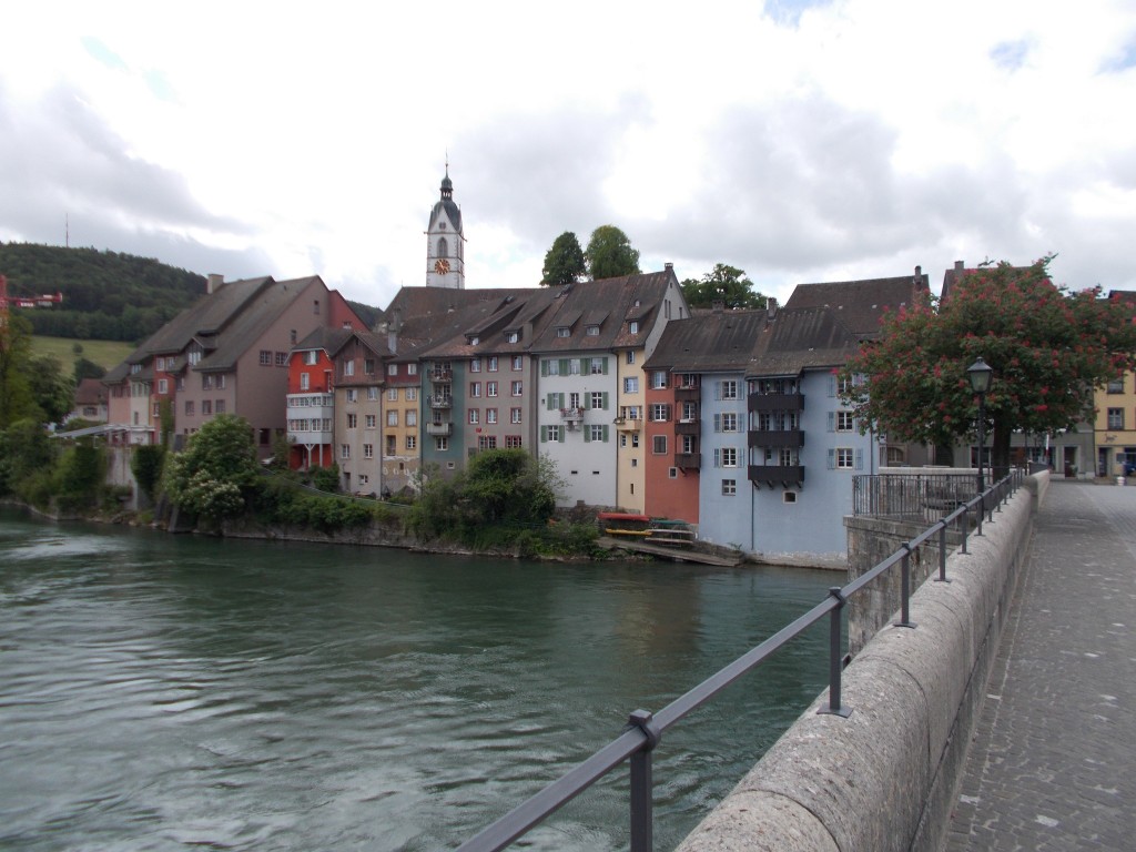
With the trail still flat, we crossed another bridge back onto the German side of the Rhine and continued riding. Passing several small towns and riding through some small farm areas, the town of Laufenburg soon burst into view. Half German and half Swiss, Laufenburg became our first real stop of the day having ridden basically continuously since we set out from Waldshut.
Laufenburg from a distance. Spanning the Rhine, half of this town is in Switzerland and the other half is in Germany. Full of colourful buildings and bakeries, it’s a perfect place to stop for a break. Laufenburg, Germany – May 11, 2104.
As it turned out, stopping in Laufenburg was an excellent decision. Not only was it incredibly picturesque (as so many towns on the Rhine are), it also turned out to be a great town to explore.
Crossing onto the Swiss side of Laufenburg, we stopped to take some pictures from the bridge and then began exploring the streets on the Swiss side as they slowly rise up a hill.
The colourful buildings on the Swiss side of Laufenburg as photographed from the bridge over the Rhine. Laufenburg, Switzerland – May 11, 2014.
Riding through Laufenburg, we caught the scent of a bakery and chased the smell through town to locate its source. Having ridden for over an hour, we pulled up for an early lunch at a local cafe and had some of the local pastries, cautiously eyeing the sky as we ate.
The clouds had been steadily filling in since we set off, but there hadn’t been any rain….yet. It made for perfect riding temperature, but with the threat of rain looming, we decided to push on, rather than linger and get soaked. Weather on the Rhine always seemed to be highly regional, so even on a bike, it seemed we were able to skirt around bad weather on occasion if we hastened or retarded our pace.
Crossing back to the German side of the Rhine, the route climb slightly and then descended back to the side of the river, passing through the town of Murg and then on through some farmland. The route was easy and generally flat. Paired with excellent signposting and the cooler temperature, we were making excellent time.
Pushing into the outskirts of Bad Säckingen, the long covered bridge between Bad Säckingen, Germany and Stein, Switzerland came into view.
Holzbrücke Bad Säckingen photographed from a distance. Used only for pedestrians (and cyclists) this bridge is the longest roofed bridge in Europe and connects the towns of Bad Säckingen, Germany and Stein, Switzerland.
Minutes more and we were in the central town square, the skies above still trying to close in on us.
The central town square in Bad Säckingen, Germany. As it was a cloudy day the streets weren’t as busy as they likely would be at other times. Had we lingered, this would’ve been an excellent place to stop for some lunch.
Bad Säckingen had a very charming town square and the St. Fridolins cathedral provided a great opportunity to take some pictures. Furthermore it would’ve made a great place to have some lunch as there were many cafes and shoppes. Given that it was Sunday though, many of them were closed. Next time.
Beyond the town square, the route crossed back into Switzerland through the long covered bridge. As it is fully covered, and only had small windows, we rode slowly through the bridge so as not to have a collision with the pedestrians within and take the time to admire the timbers within.
Emerging on the other side, we rode into Stein and located the train station. Here we boarded a train headed into the Swiss interior to visit some friends who lived in the area, planning to return the next day to Stein and finish riding the remainder of Switzerland into Basel.
It had been a short day, but full of highlights nonetheless.
Day’s Stats
Distance ridden: 33.47 km
Max speed: 47.8 km/h
Average speed: 15.2 km/h
Seat time: 2:11
Total distance: 528 km
As planned the previous day we started out by backtracking about a kilometre to check out the city of Schaffhausen. A much larger city than any we’d been through in a while, Schaffhausen allowed us opportunity to do some great shopping at its excellent morning market. We filled our panniers with food, ate some pretzels, and then were back on the route.
Crossing again to the south side of the river, the route winds through a forest for a few kilometres as it gently climbs up the hill that holds Schloss Laufen and forms one bank of the mighty Rhine Falls.
Having peered into the valley, we quickly realized that the best view of the Rhine Falls below was on the other side of the river. With no crossing points nearby, we opted to continue our ride further downstream hoping to find both a place to cross and a way down to the bank of the river.
Finding a bridge turned out to be rather easy. After following a lesser used trail that went down to the river bank over a few hundred metres, we were able to spot a small pedestrian bridge that crossed the Rhine. Taking the bridge, we then began to backtrack towards the Rhine Falls on a small footpath that looked to run along the bank.
The footpath quickly turned out to be a poor decision as we hadn’t gone but a short distance and had to shoulder our bikes down some stairs and then push them by hand on a very narrow trail that was just inches from the river bank. One missed step would’ve resulted in a very large splash and a very wet bike.
Still, we persisted, and within time the trail we were on arrived in the main tourist viewing area for the Rhine Falls. We parked the bikes, got out a bunch of food and just enjoyed the view for nearly an hour. The falls were awesome, and with Schloss Laufen now fully visible on the hill above, it was a great time to take some pictures.
A snapshot of the Rhine Falls. Gorgeous. A perfect place to stop for a snack. Rheinfall, Switzerland – May 10, 2014.
Leaving the falls we found a different way back to our small bridge (on a road this time, thankfully) and crossed back to the south side of the river to rejoin the route. Our day from that point on consisted almost entirely of riding alternating villages and meadows along the Rhine gorge.
I really enjoyed this section of the Rhine. Great farmland. It was a very nice day as well, so we were having a blast. Lots of great little Swiss towns.
Exact location unknown, but a good shot nonetheless of how the Rhine valley looks on this section of the Rhine. The valley has completely widened with the mountains and Lake constance now very far behind. Forests are still abundant, and with each passing kilometre the Rhine seems to get larger. Once a stream, the Rhine becomes a mighty river. Switzerland – May 10, 2014.
After riding about three and a half hours past the Rhine Falls, we found ourselves in the Swiss town of Koblenz (not to be confused with the much larger city of Koblenz in Germany). Finding no accommodation there, we crossed the river into the German town of Waldshut and quickly found a hotel.
With some daylight still left, we decided to ditch our bags and ride further into Waldshut to find some dinner. This was the first time I’d ridden the Surly without its panniers since leaving home. That night, it felt like the fastest bike in the world. We found the main market street of Waldshut further downstream and had some pizza.
Day’s stats
Distance ridden: 69.43 km
Max speed: 68.6 km/h ???? – cycle computer must’ve made an error.
Average speed: 15.6 km/h
Seat time: 4:26
Total distance: 494 km
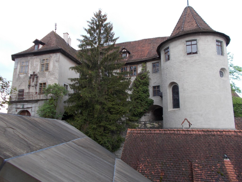
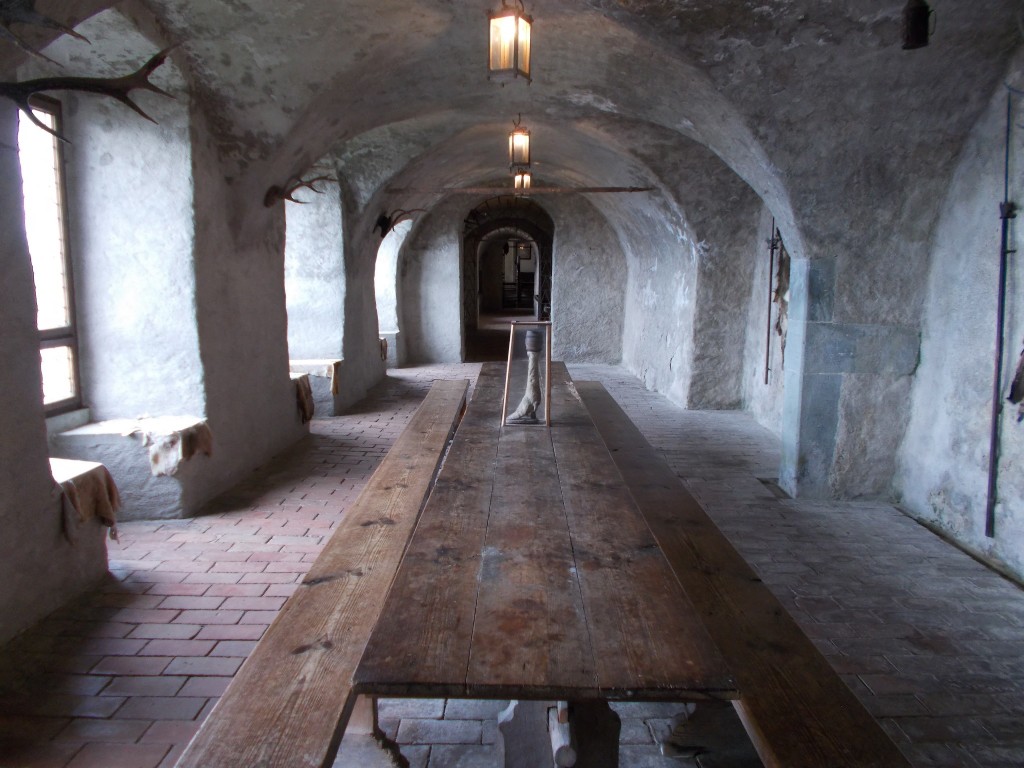
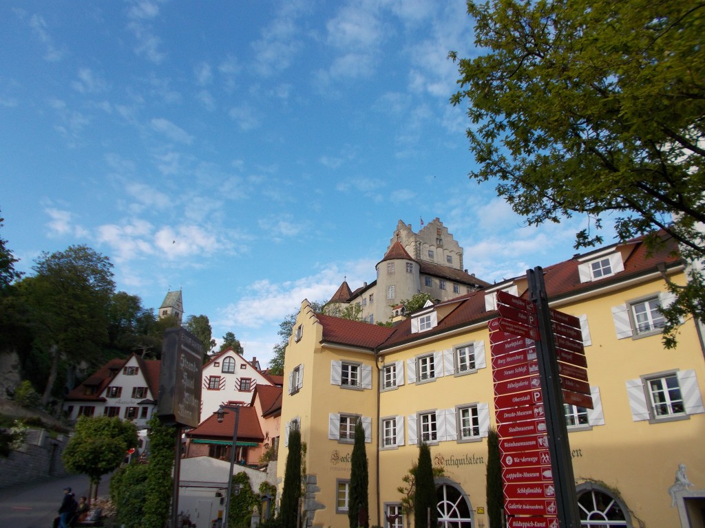
Straight away we power down the hotel breakfast and leave the bikes at the hotel to run into town to do a tour of Burg Meersburg. This lovely castle is still inhabited and is accessible by a paid tour. Not sure how much of the castle we would get to see, we bought tickets and were not sorry that we had. The tour took more than an hour to complete and gave us a good taste of the many regions within the castle walls. Highly enjoyable.
The beautiful exterior of Burg Meersburg. This castle, still inhabited, has been very well maintained and a large portion of it is viewable on a tour. Worth a visit. Meersburg, Germany – May 9, 2014.One of the dining halls in Burg Meersburg, ideally located to allow for lots of natural light. And yes, that is a goblet made out of an animal’s foot on the table. Meersburg, Germany – May 9, 2014.
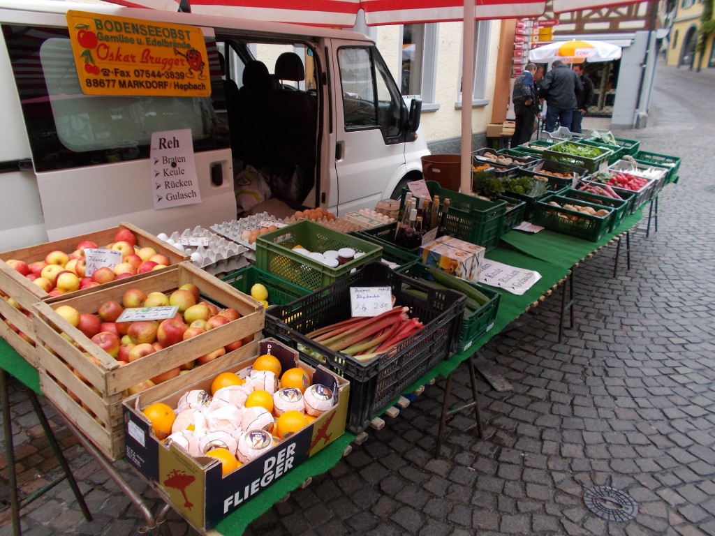
Returning to the hotel, we wasted no time in gathering up our bikes and quickly rolling into town to catch the morning market. Several vendors had set up shop allowing us to procure some more fruit, meats and vegetables. Street markets are a cyclists best friend because they enable the quick purchase of much needed sustenance. Thanks to the local high standards, the food we purchased at street market was always top quality and reasonably priced. Buying at such vendors from your bike seat is far easier than finding a place to lock up and heading inside a larger store (which are few and far between anyway).
A snapshot of one of the many vendors that arrived in Meersburg in time for morning shopping. Markets like this were a common scene in many of the towns we visited, and the quality of the goods they sold was always top notch. A great deal of our food came from places exactly like this. Some fruit, veggies, cheese and cured meats are perfect out on the road and keep well within a pannier. Meersburg, Germany – May 9, 2014.
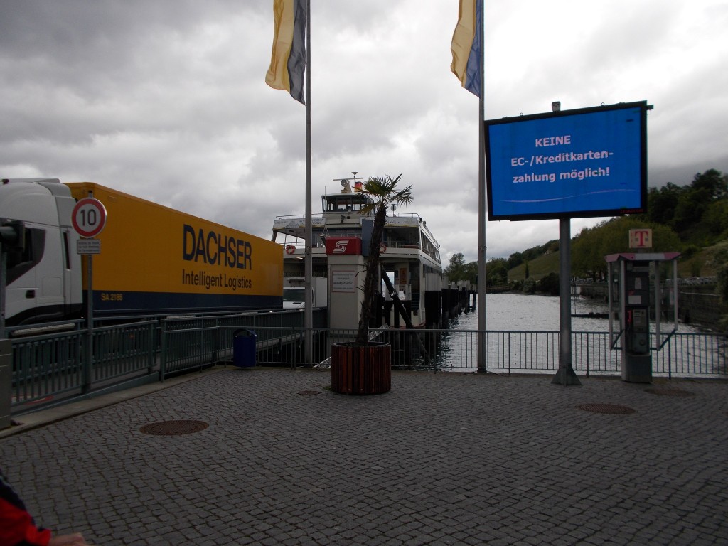
Our food restocked, we rolled down the steep slope that leads away from the centre of Meersburg and located the ferry slip at the water’s edge. As Lake Constance is so large, the ferry crosses from Meersburg to the town of Konstanz. Though it would be possible to ride around the north end of the lake through Bavaria, this would almost certainly add an extra day of travel and is not part of the posted route. Perhaps I’ll try that on another trip. The ferry costs only a few dollars to take and the journey across takes mere minutes.
Waiting to board the ferry in Meersburg that would carry us to the city of Konstanz. Officially part of the route, taking the ferry negates the need to ride through Bavaria all the way around the north end of Lake Constance. Choosing not to take the ferry would likely add about a day of riding. Alternatively, it is possible to ride on the Swiss side of the lake and therefore avoid the need to take the ferry at all. This route, however, would not allow a visit to Meersburg, Friedrichshafen and the many other great towns that dot the Bavarian side of the lake. Meersburg, Germany – May 9, 2014.
Rolling onto the ferry, we note that the wind is starting to pick up; wind that would stay with us for the rest of the day.
Arriving in Konstanz, we pedaled in a surge of traffic up a hill away from the ferry slip. Nothing gets the blood pumping like a few dozen cars eager to disembark the ferry behind you. Riding uphill for a short distance, the route then turns slightly and gently descends into the heart of the altstadt (old city) of Konstanz. Though easy to ride directly through, this area is worth stopping in to see the architecture and take some pictures. The cathedral in particular is worth a look as it contains some highly intricate stonework throughout. This cathedral was unique among the others that we saw as it also allowed for limited access to the basement level which was fun to see.
Leaving the old centre of Konstanz, the route loosely followed the shoreline and railway as it plunged back into Switzerland. Back in Switzerland, the route turned sharply west and began again to wind back to the edge of the lake as it slowly narrowed back into the Rhine. Farmland slowly began to be a frequent scene again as we rode in the wind through several small Swiss towns.
Swiss cows happily jingling their neck bells at a small farm we stopped at to buy snacks. A frequent sight in the early stages of the Rhine, cows like these fill the valley with the sounds from their neck bells. I never tired of it. The Swiss farmland was my favourite place to ride of the entire trip. Steckborn, Switzerland – May 9, 2014.Swiss farmland with the town of Eschenz, Switzerland in the distance. This section of the route loosely follows the Rhine as it hops from town to town through the gentle rolling hills. Very enjoyable riding. Near Eschenz, Switzerland – May 9, 2014.
After some time, and several snack stops, we found ourselves in the town of Stein am Rhein admiring the beautifully painted buildings that line the main market street. Stopping in Stein am Rhein is very much worth the time as the buildings are decorated in such a way that you will not see as much of in any other town. A great place to take pictures, and they have a bike shop.
A must see town along the route, Stein am Rhein is home to many buildings that have been decoratively painted similar to the ones shown. This Swiss town is also home to a bike shop and lots of places to buy provisions. A perfect place to pull up for a snack and take some pictures. We met a couple here that were completing the Rhine route with their two sons, aged about 2 and 4 years old. Parenting win! Stein am Rhein, Switzerland – May 9, 2014.
Now on the north side of the Rhine, we rode through more farmland and small towns as the wind continued. The sun shone brightly and it was otherwise a very nice day, so the wind didn’t have a negative affect on the day’s mood.
Coming away from some fields, the route turned to gravel as we ascended gently into a gorgeous forest. Our first real opportunity to ride in a thick wood, this section of the trail was a real treat and seemed to end all too soon.
Swiss farmland very near the Swiss / German border on the north side of the Rhine. Just a few hundred meters ahead, the Rhine river returns to view. Though rare, certain sections of the bike route do require riding on gravel roads, but this is largely uncommon and wasn’t at all unpleasant. The scenery is so spectacular, you won’t be focusing on what’s under your tires. A few kilometres outside Hemishofen, Switzerland – May 9, 2014.
Emerging on the other side, we soon found ourselves across from the town of Diessenhoffen. With daylight starting to fade, we opted not to stop and pressed on just past Schaffhausen to spend the night in Flurlingen. Weary from the wind, we ate at the hotel (which was delicious) and had an early night agreeing to backtrack a few minutes on the morrow to see Schaffhausen properly.
The town of Diessenhofen, Switzerland and its covered bridge photographed from the German side of the Rhine. We weren’t able to stop here, but it looked like a very nice place to visit. I’ll make a point to stop there next time. The pathway is typical of much of the Rhine route; off street and well maintained. Diessenhofen, Switzerland- May 9, 2014.
Day’s Stats
Distance ridden: 59.09 km
Max speed: 40.9 km/h
Average speed: 16.3 km/h
Seat time: 3:36
Total distance: 425 km
Thanks to the involuntary kilometres completed the day before we knew the day’s ride would be a short one. No matter. The extra time would be well spent poking around little shops and eating chocolate.
After an awesome breakfast at the hotel we returned to our bikes to find them in a sorrowful state. Dirt and grit everywhere! Riding in the rain sure has a way of helping grit find its way into every nook and cranny on a bike. Hoping to nurse some liveliness back into our machines we spent our first fifteen minutes checking everything over and cleaning and lubing our chains.
Leaving the hotel we headed straight downhill to rejoin the water’s edge and the route, stopping only briefly so that #1 could mail his box of LPs home. Back at the shore, we rode right out onto the island that is accessible by bridge from Lindau’s shoreline. Beautifully developed, this island is home to numerous shops and market places. Very worth the visit. A highlight of the stop: The stunning ceiling and courtyard of Münster Unserer Lieben Frau:
The lovely town square that sits immediately in front of Münster Unserer Lieben Frau. Lindau, Germany – May 8, 2014.My best attempt at photographing the beauty to be found within Münster Unserer Lieben Frau. A pocket camera really has no hope of doing it justice. Worth the stop. Lindau, Germany – May 8, 2014.
Leaving the island and Lindau itself, the route began to climb slightly back into the hills as we wound through small towns bordering the lake. It was a beautiful day and spirits were high. Having done another 10 kilometres or so, we stop again to eat cheese and sausage before continuing.
The scenery on that part of the ride was very good. Lots of vineyards and farms. Absolutely perfect for riding, and after just a few more small towns, Friedrichschafen came into view.
Though a city of reasonable size, the route skirts nicely through Friedrichschafen by mostly adhering to a bike route that follows near the water’s edge. Distance was covered very quickly, and before long we found ourselves in front of the Zeppelin Museum.
Among other things, Friedrichschafen is known for being the location Ferdinand von Zeppelin established his factory to produce Zeppelin airships. The museum contains a great collection of exhibits and stories about the Zeppelin company and Germany’s contributions to airship technology. It’s a very interesting place and a must stop for anyone interested in aeronautics.
A snapshot of the exterior of the Zeppelin Museum in Friedrichschafen, Germany. This small museum is right on the Rhine route and is worth a stop for anyone interested in flight. Many interesting items and stories within. Friedrichschafen, Germany – May 8, 2014.
Thank goodness we had a short day of riding, because we spent far longer in the Zeppelin museum than planned.
Back on the bikes, the route continued to track within sight of the water as it wound through the remainder of Friedrichschafen and back into the countryside.
More vineyard, more small climbs, more stops for snacks. I was loving the scenery. And importantly, I was falling more and more in love with my bike each day. The Surly steel frame was always completely comfortable. Thanks, Surly!
Putting the countryside behind us once more, Meersburg castle popped into view as we coasted down a tree-lined gentle decline into Meersburg. Glancing at my cycle computer, I took note that we had only done just over 50 kilometres; a short day in terms of distance, but filled by all we had seen. Gotta love Europe: So much to see!
A shot from waters edge up into the centre of Meersburg with Burg Meersburg prominently visible. This beautiful castle is still inhabited and a great tour is available. Meersburg is very pretty and the castle is no exception. Meersburg, Germany – May 8, 2014.
The simple fact of the matter is that the Rhine holds such a vast array of treasures that it would be impossible to ride this route too slowly. At no point on our trip did we find ourselves wanting for more things to see. The distance covered on Day 5 could have been easily dispatched in two hours of leisurely riding, but it took us all day. When I go back, I think I’ll ride the route even slower.
Meersburg, for the record, is a beautiful town, like many others that we saw. Home to a still inhabited and well-maintained castle, this touristy medieval town is home to many cute streets and great food.
A quick snapshot of a typical street in Meersburg, Germany. Slightly touristy, this small German town is bursting with character and charm. We greatly enjoyed walking these streets, and a restaurant here served what was easily among the top 3 best meals we had on the trip. A perfect place for an overnight halt. Meersburg, Germany – May 8, 2014.A view out into Lake Constance from the water’s edge in Meersburg. This turned out to be a great place to watch the sunset and catch a few quiet moments before dinner. The entire town and the views of the surrounding area are all very scenic. Meersburg, Germany – May 8, 2014.
I knew were were going to love Germany, but at that moment we were also excited to start the next day which would see us take a ferry across the lake to ride on Swiss soil for a few more days. Perfect. I was missing those cow bells.
Day’s stats
Distance ridden: 51.2km
max speed: 39.2 km/h
Average speed: 17.7 km/h
Seat time: 2:53
Total distance: 313km
Having emerged from our hotel, we find it raining steadily. Lovely. On goes the rain gear.
Leaving Buchs, the route meandered through several small villages and more farming area before descending to the rivers edge and joining a bike path that leads all the way to Austria and Lake Constance. This part of the path is cinder, not asphalt, so with the rain pelting down I held a mental funeral for my bike’s cleanliness.
Sigh.
The rain was steady, and heavy at times. Add in some lower temperatures, the odd gust of winds, and it was clear that mother nature was trying her best to dampen our spirits.
Positivity still reigned though, and despite being cold and wet, we were still enjoying ourselves. Furthermore, the rotten weather meant that the trails were completely devoid of other riders, so we didn’t even have to worry about traffic.
We stopped for our morning snack under a large bridge. Cheese, sausage, bread, and chocolate. The wind drove the rain underneath the bridge. Shivering. More chocolate.
Back in the saddle, things were pretty unpleasant for a while more. I couldn’t feel my fingers.
Would I have rather been some other place?
Nope.
A few kilometers further, we make the decision to detour from the route into Altstätten for further provisions and to see the town. This turned out to be very worth the few extra kilometres.
Climbing gently into town, we stopped to have lunch at a local restaurant. The proprietor was a lovely lady as old as time. I ordered the special from the blackboard out front. Soup. Salad.
The soup came. Good.
The salad came. Very good.
The shin stew, garlic mash, and sateed kale came. Wah?
I already felt quite full after the soup and salad, having previously laid waste to a healthy quantity of cheese, sausage, and chocolate under the bridge not long before. No matter. I powered through the extra food. Added calories never hurt on the bike. We quickly guess that due to the language barrier my order had been misunderstood.
For the record, the shin stew was epic. Best ever. Mash and kale good too.
Our bill came, showing one order of the special. Still slightly confused, we pay and walk outside to discover my view of the specials board had been obscured. The stew was mentioned, but so far down I hadn’t even seen it. Wouldn’t have ordered it if I knew how much food was at hand, but I’m sure glad I did. Best mistake ever.
On the way out of town, a quick stop for more cheese. End up buying some fresh buttermilk as well. Was loving every bit of food. All great stuff.
Nearing the outskirts of town, we come upon a large Salvation Army store and spend several hours digging through their rather large collection of old Vinyl LPs. #1 ended up with about a dozen albums and continued the ride with them stacked and strapped to his rear rack. A little extra weight on a touring bike is always okay. There’s lots of treasures along the Rhine.
Rejoining the route we ride several more kilometeters, mostly straight, finally reaching the Rhine’s entry into Lake Constance. At this point the route turned to the east, then north again as we entered Austria.
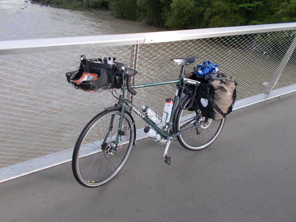
The author’s soggy Surly Disc Trucker a short while after entering Austria having left behind hours of riding in the rain. The photograph does a good job of hiding the thin film of dirt that covered the bike. Photo taken on a bridge in Austria between the cities of Hard and Bregenz. May 7, 2014 – Bregenz, Austria.
Riding this section was very enjoyable. After entering Austria, the route passes through a nature park and then follows the bank of Lake Constance all the way to Bregenz. Most of this area is public parkland, so the riding is easy and there’s lots to see.
The view towards Lake Constance from a bridge between the Austria cities of Hard and Bregenz. On the right is the fringes of a nature park that is very enjoyable to ride through and contains many great picnic locations. The clouds above were parting having spent the day burying the region in rain. May 7, 2014 – Bregenz, Austria.One of the many small harbours that dot Lake Constance’s shoreline within Bregenz. I gather that it may have still been too early in the year for the main boating season as we didn’t see too many coming or going. May 7, 2014 – Bregenz, Austria.
Our plan was to spend the night in Bregenz, and with the rain starting to let up, we rolled into town hoping to find a place to stay. We visited several hotels in the town centre; all full. Thoroughly famished, we stopped for a falafel at a local eatery and then continue our search for accommodation, eventually resorting to using a phone to call around rather than riding between each hotel.
Everything was full. An architect convention was in town.
Cripes.
At that moment I recalled what many blogs had indicated: No matter how much you plan, sooner or later you’ll have trouble finding accommodation and have no choice but to press on….in the dark.
Darkness was falling, and we had no choice but to press on. This is exactly why lighting is a must have item for any bike tour. Plan as you might, you never know when you might find yourself having no choice but to pedal under the cover of darkness.
Lights on, we make a few more calls and finally find a hotel with vacancy about 10 kilometres further up the route in Lindau. With the darkness now complete, we leave Bregenz at full clip.
Rejoining the route, we kept a blistering pace through the dark. The path was on the side of a busy road and in poor condition in places. It was exciting at times. Slightly sketchy at others.
Re-entering Germany, we left Austria forever behind, having only been there a few hours. With the rain trying to return, we rode into Lindau and climbed up to our hotel. Despite the dark, we had no trouble finding the place. Good fortune, on a day that had tried its best to dismount our enthusiasm.
The hotel was beautiful, but very old, and probably haunted. I didn’t care though. Sharing my room with a ghost seemed much more appealing than sharing it with an architect.
Our rain gear had worked very well. For the most part, I was dry, and so was all my gear safely tucked away within my epic Ortlieb panniers. My bike was a mess.
Drank the buttermilk before bed. Perfect.
Day’s stats:
Distance: 79.25km
Seat time: 4:27
Average speed: 17.7 km/h
Max speed: 31 km/h
Total distance: 261km.
Another day of great weather. Who said coming to Europe in the Spring would be a bad idea?
I was quite happy to be heading out of Chur. Stuffy. Missed that open country air. Barnyard > car exhaust.
On our way out of town, we stopped at several stores to buy some necessary supplies. It’s worth noting that central Chur is home to several great cycle shops; a key stop if ever a tourist is in need of some repairs.
Rejoining the route at Chur’s main rail station, we thread our way through several urban streets before joining a designated bikeway that took us back towards the Rhine. The route follows the Rhine, though runs more closely to a large highway. The pathway is relatively straight and clear, so this is a great segment to do at speed. It didn’t take us long to put Chur about 10 kilometres behind us and find ourselves back in smaller towns and farmland. The riding had been flat. My legs were grateful.
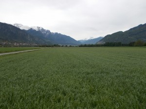
Coming into the area surrounding Igis, I noted that the valley had widened and that the hillside ranches were slowly giving way to grain fields and expansive vegetable plots. Some of the grain looked within a month of harvest. The Swiss really take agriculture seriously. I had heard there was still snow on the ground at home in Canada. I thought again about the merits of moving to Switzerland. Absolutely stunning, and a seemingly ideal climate.
Just before heading into Igis, we stopped for some lunch. The sunshine, grass, and wind made fine dining companions.
The location of our first big snack stop on Day 3, just outside of Igis. The Alps in the background made an ideal backdrop for a great break from riding. Together with the food we still had from the villages before Chur, this rest break became one of my all time favorites of the entire trip. Now well out of Chur, we were back into farming country, which I grew to greatly prefer. May 6, 2014 – Igis, Switzerland.
For lunch: Sausage, cheese, bread, oranges, and a carrot. I noticed that my pannier was already starting to smell like a deli. Liked that. I’ll never wash it.
Passing through Igis, the route turns and heads back into the hills. Short climbs, epic views.
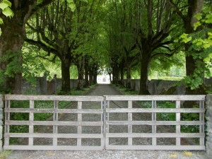
First castle sighted. Private residence. As the castle was mostly obscured from the roadway, and not wanting to trespass in case they still had an archer on staff, I opted to take a snapshot of the postcard perfect driveway.
A stunning driveway to a small castle just outside of Igis, Switzerland. Beautiful. May 6, 2014 – Igis, Switzerland.
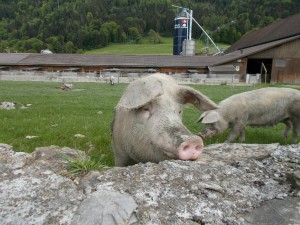
Immediately next to the castle, a lovely pig farm. We stopped to become acquainted with the locals. Lovely critters.
A large hog in the yard of a pig farm just outside of Igis, Switzerland. This particular one was quite social and visited with us for a few minutes before resuming eating. In a world where plenty of food animals live in relative squalor and cruelty, these pigs have it very good. Lots of open field to roam within and access to lots of sunshine. – May 6, 2014
Leaving the farm, the route briefly re-enters some wooded area and crosses a small river before beginning to climb again.
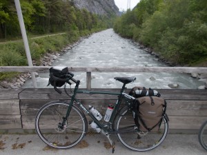
Behold the unadulterated beauty of the author’s (utterly majestic) Surley Disc Trucker in full touring mode. This is the last photo taken of the bike before the weather turned sour the next day and forever spoiled the utter perfection of new bike parts. The photo was taken over the river Landquart which feeds the Rhine just a few kilometers downstream. May 6, 2014 – Malans, Switzerland.
As we climbed, the view of the valley below got better and better. I greatly enjoyed looking down on dozens of Swiss farms as we climbed gently up the hillside.
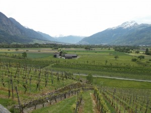
Then, all of a sudden, vineyards!
…
A Swiss vineyard along a hillside just as the route is about to enter Malans. We saw hundreds of these vineyards through this part of the Rhine, and though it was only May, they looked to be well on their way to a great crop. May 6, 2014 – Malans, Switzerland.
Had we taken a wrong turn and ended up in the Mediterranean? Switzerland’s climate continued to surprise me. Epic snow in the winter, with a spring and summer that must come on strong. Locals are able to have a gnarly ski season and then move right into sowing a righteous garden. As someone who dreams of little more than a killer garden, open country and a full root cellar, I felt a hint of jealousy as I reviewed the local scene. What a great country.
The vineyards continued for a while, spackled with small towns along the way. We made regular stops to eat chocolate, a habit that became hard to break when our total journey concluded.
Soon, a steady descent began back down to the valley floor. This descent was far tamer than the ones of the last two days, but still great fun.
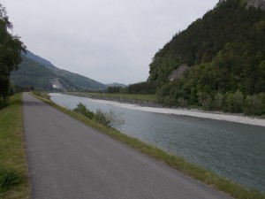
Leaving Bad Ragaz, the route follows closely to the river for a 13km straight shot, then enters Liechtenstein. Though long and straight with relatively uniform scenery, this straight section is anything but boring. The scenery is still very good, and it provides a great opportunity to bring the speed up a bit and give the legs a bit of a workout; a great way to earn the next chocolate bar…or three.
A very long and relatively straight section of the bike path just outside of Bad Ragaz, Switzerland. Though very straight and flat, the scenery in the valley is quite good at times and can be covered at a solid place. A great section to open up the taps and push hard for an hour or so. Not far ahead Liechtenstein is entered. May 6, 2014 – Bad Ragaz, Switzerland.
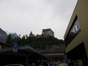
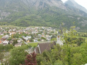
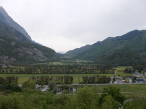
Entering Liechtenstein, we found villages and countryside essentially identical to Switzerland’s. Riding for just a bit longer, we spot a huge castle atop a hill in Balzers and decide to get a better look. Leaving the route, we cycle into Balzers along the highway and climb a steep hill to find ourselves in the castle yard. The view was completely worth the climb.
Schloss Gutenberg as seen from the town of Balzers which surrounds it. May 6, 2014 – Balzers, Liechtenstein.Part of the city of Balzers taken from atop the hill that holds Schloss Gutenberg. Many great views can be had. Well worth the short climb. May 6, 2014 – Balzers, Leichtenstein.One of the many spectacular views from the Schloss Gutenberg hill. Located at a high point in the immediate area, it’s possible to get great views in almost every direction. Like Switzerland, Liechtenstein is very pretty. May 6, 2014 – Balzers, Liechtenstein.
Leaving Balzers, we rejoin the route alongside the Rhine (which has widened greatly) and ride quickly along the bike path that follows the river. Most of this section is a straight shot, so again, it’s a great place to make up some time. In very little time at all, we passed through Vaduz to take in some more of Liechtenstein.
Vaduz is a very nice place, but due to it being later in the day, we didn’t find many things open. Though we had officially left the Rhine route to explore the town, navigation was not difficult, and we were able to rejoin the route by following some signs indicating the bikeway back to the river.
Rejoining the Rhine route, we find that the route immediately crosses the river heading back into Switzerland and the Swiss town of Buchs. Climbing slightly, we ascend through Buchs to find our overnight halt. Along the way, we cycle through Buchs’ main shopping district with a wide street and walkways lined with dozens of shops. Reminded me of State Street in Santa Barbara, for some reason.
Stashing our bikes at our hotel, I note that the sky is starting to grow close again. Will it rain?
Day 3 Stats
Day’s distance: 68.71 km
Average speed: 17.6 km / h
Max speed: 52.5 km / h
Total distance: 182 km
Seat time: 3:53